Pyrgos (Lm) the Early-Middle Bronze Age Necropolis, from Tomb 1 to Tomb 19
by Maria Rosaria Belgiorno
Some information about the necropolis and the tombs
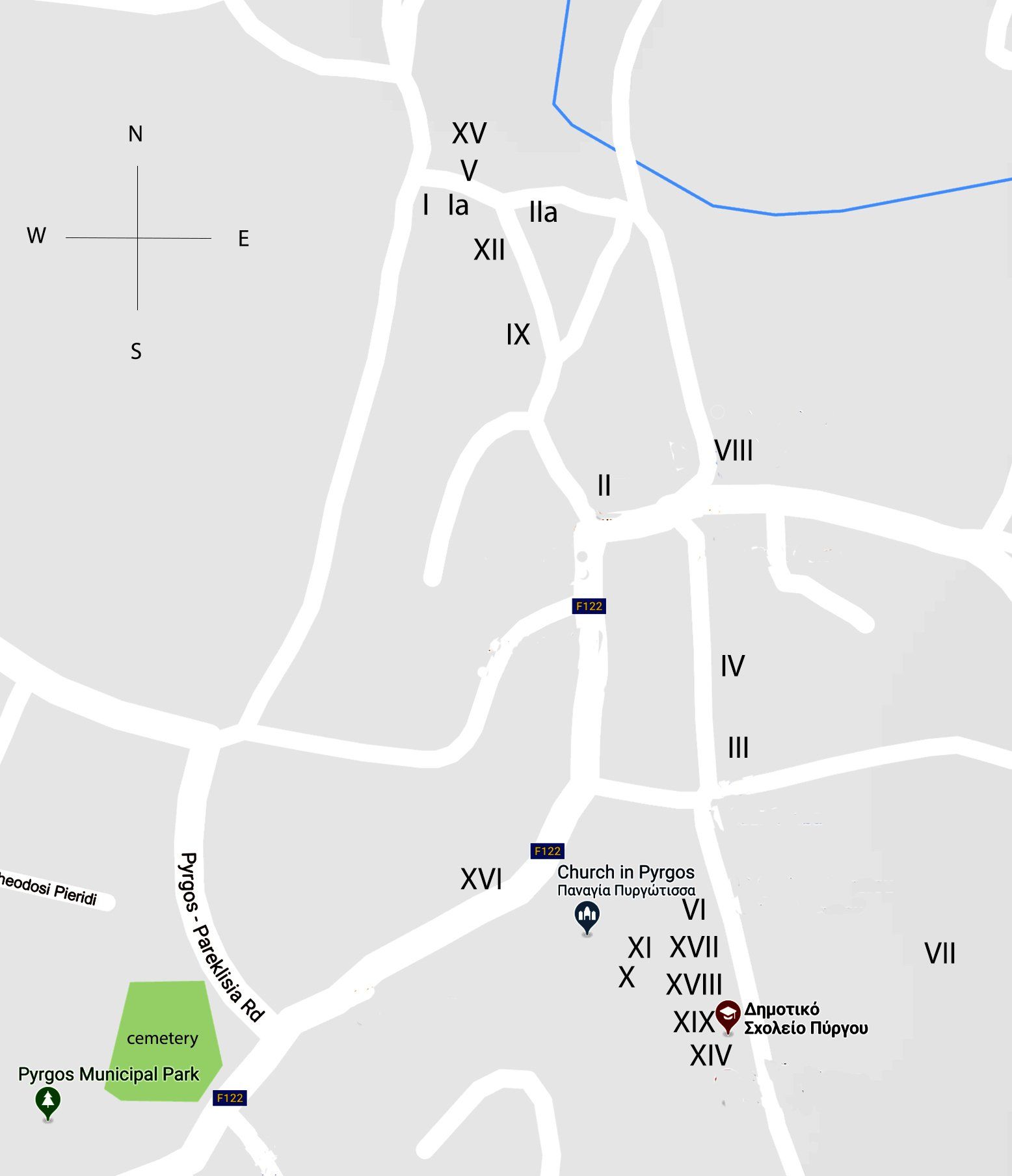
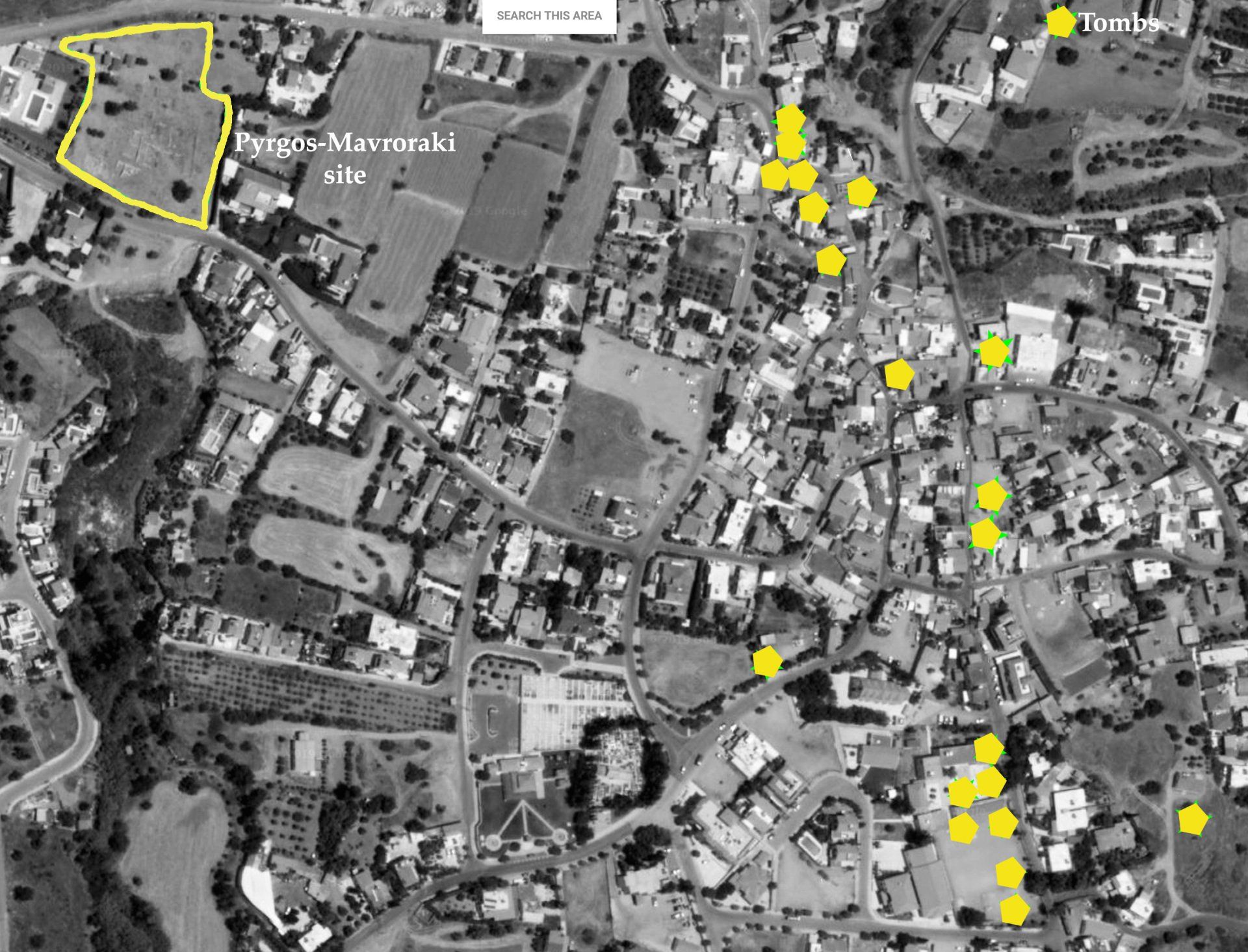
The cemetery is located in the centre of the old village distributed along a Nord South axis (Fig. 1) to the East of the Early Middle Bronze age settlement. All the graves are pits, dug in the havara to a variable depth that originally did not exceed a meter and a half from the surface. The entrance was lateral or from the top, devoid of any architectural reference to the surface. Some tombs contain burials carried out in later periods, probably by the same family, according to a custom well known throughout the island. The largest number of tombs have been found in the area between the Church of Panaghia, the modern cemetery and the elementary school (Fig. 2).
Surveys carried out by H. Catling and N.P. Stanley Price traced an interesting map distribution of the prehistoric occupation of Limassol territory, incremented by the surveys of the French Mission at Amathounte around the villages of Ayios Thyconas, Parekklisha, Monì and Pyrgos.
Most interesting for the possible connections with the settlement of Pyrgos/Mavroraki and the necropolis under the houses of the modern village is the Bronze age settlement of Bouthomandres in the Monì territory[, the remains found at “Vasilikà” locality at south east of Pyrgos between the sea and the Monì village, and the Chalcolithic-Bronze age material found near the ancient Chapel of Aghia Marina[, 2 km south east of Pyrgos, where in 1992, another cemetery was reported 360 meters southeast from the church, during the survey performed by Catherine Petit and Pierre Yves Pechoux[.
The temporary conservation of the material coming from Pyrgos’ tombs in the storage-room of the Cyprus Museum in Nicosia before the delivering to the Limassol District Museum caused some confusion in the numbering. When the material and the relative documentation was finally transferred to the Limassol District Museum in 1978 the existence of two tombs with n°1 and two tombs with n°2 was an unlucky reality. Furthermore, as it was not possible to change the progressive inventory numbers of the vases the tombs have been identified as Tomb n°1, Tomb n°1a, Tomb n°2 and Tomb n°2a. All the documentation is saved in the Register books of the museum, including the original manuscript notes, maps and drawings made during the rescue excavations.
In 1993 the discovery of Tomb 21 with hundreds of potteries crushed by a tractor fallen inside the room, attracted my attention for the repertoire of bronzes and stone tools probably belonging to a blacksmith. The restoration of the objects took more than two years. Furthermore, the first group of the tombs and the Tomb 21 were distinctly published in the limits of 35 pages on the RDAC in 1997 and 2002.
The unexpected discovery of Tomb 21 in the north-western part of the village, containing a selection of 13 different bronze objects and the stone tools for working the metal has been very important for the location of the settlement and the understanding of the role of Pyrgos as a metallurgical site (Belgiorno 1997b). Even if the stone tools were compatible with the final phase of bronze working (hammering, cleaning and polishing the objects), they suggested the presence of a copper workshop in the area connected with the mineral resources of the surrounding territory. In next years, the opening of the excavation at Mavroraki 300m West of Tomb 21, demonstrated the hypothesis was correct and Pyrgos was probably a main centre of copper production on the south coast of Cyprus in the Early and Middle Bronze age.
Pyrgos (Lm) the Early-Middle Bronze Age Necropolis, from Tomb 1 to Tomb 19
by Maria Rosaria Belgiorno